Merrifield MN
Merrifield MN – Paul Bunyan Trail Towns
| Segment 1 |
The beginning of the Paul Bunyan Trail is Segment 1. From mile markers 0.0 to 14.3 covering areas from Brainerd, Baxter, Merrifield, to just north of Nisswa. |
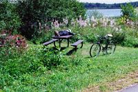 Mollie Lake rest area. Mile 10.5 |
 The unincorporated village of Merrifield, a part of Lake Edwards township, is about nine miles north of Baxter and had a population of 140 as of the 2010 census. The settlement was named for William Merrifield, an early veterinarian at the Campbell Logging Ranch. seasonal and permanent residences and a resort are located adjacent to the west edge of the rail right-of-way of the shore of North Long Lake. Several small businesses and the city park with a shelter and playground are located one block to the east along Hwy. 25.
| Trail Access and Parking Areas, and Rest Areas in Merrifield MN |
| Location | Merrifield MN (Asphalt, 10 feet wide) | |
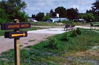
| Mile 9.0 | Parking for trail users is available at the existing DNR public water access site on North Long Lake. An information board is provided here as well. | |
| Mile 10.5 | Mollie Lake rest area. | |